HTTP 200 OK
Allow: GET, HEAD, OPTIONS
Content-Type: application/json
Vary: Accept
[
{
"id": 2,
"order": 1,
"type": "one_side_text_one_side_image",
"title": null,
"subtitle": null,
"description": "",
"items": [
{
"id": 12,
"is_text_left_side": true,
"is_text_top_side": false,
"order": 1,
"title": "Geospatial · Development · Marketing",
"subtitle": "We can help your business to",
"description": "Get Digitalized, Grow Fast & Self-trained",
"bullet_points": null,
"price": null,
"image": "https://backend.gisworld-tech.com/media/core/main_content/maincontent_image_without_background.png",
"video": null,
"image_size": "400px",
"url": null,
"mui_icon_name": null,
"redirect_text_1": null,
"navigate_to_1": null,
"redirect_text_2": null,
"navigate_to_2": null
}
]
},
{
"id": 17,
"order": 2,
"type": "video_text",
"title": "2D-3D WebGIS",
"subtitle": "Goespatial GeoAI App powered by REST APIs, ReactJS and CesiumJS",
"description": "",
"items": [
{
"id": 54,
"is_text_left_side": false,
"is_text_top_side": true,
"order": 1,
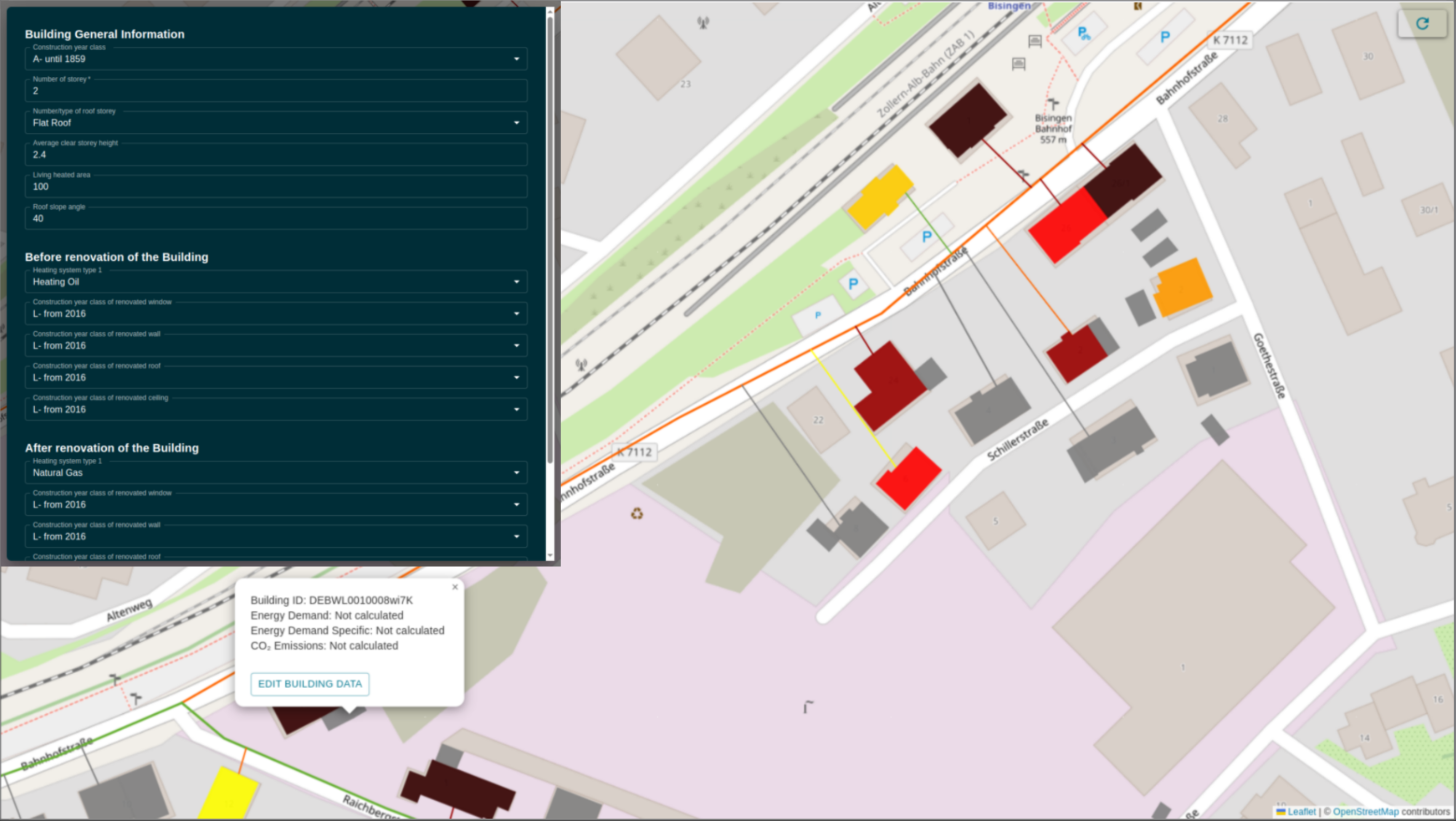
"title": "Energy GeoAI App",
"subtitle": "Smart Mapping for Heat and Energy Insights",
"description": "Track and visualize energy usage, CO₂ emissions, and heat districts in real time by GeoAI. Powered by ReactJS and Django REST APIs, our platform connects spatial data with actionable insights for sustainable urban planning.",
"bullet_points": "",
"price": null,
"image": "https://backend.gisworld-tech.com/media/core/main_content/energy_app.png",
"video": "https://backend.gisworld-tech.com/media/core/main_content/videos/intergeo_clipped_geoai_energyapp_1080.mp4",
"image_size": "300px",
"url": null,
"mui_icon_name": null,
"redirect_text_1": "Start App",
"navigate_to_1": "/web-gis",
"redirect_text_2": null,
"navigate_to_2": null
}
]
},
{
"id": 13,
"order": 3,
"type": "one_side_text_one_side_image",
"title": "3D Visualization",
"subtitle": "3D Geospatial Apps with the power of Ceiusm",
"description": "",
"items": [
{
"id": 57,
"is_text_left_side": true,
"is_text_top_side": false,
"order": 2,
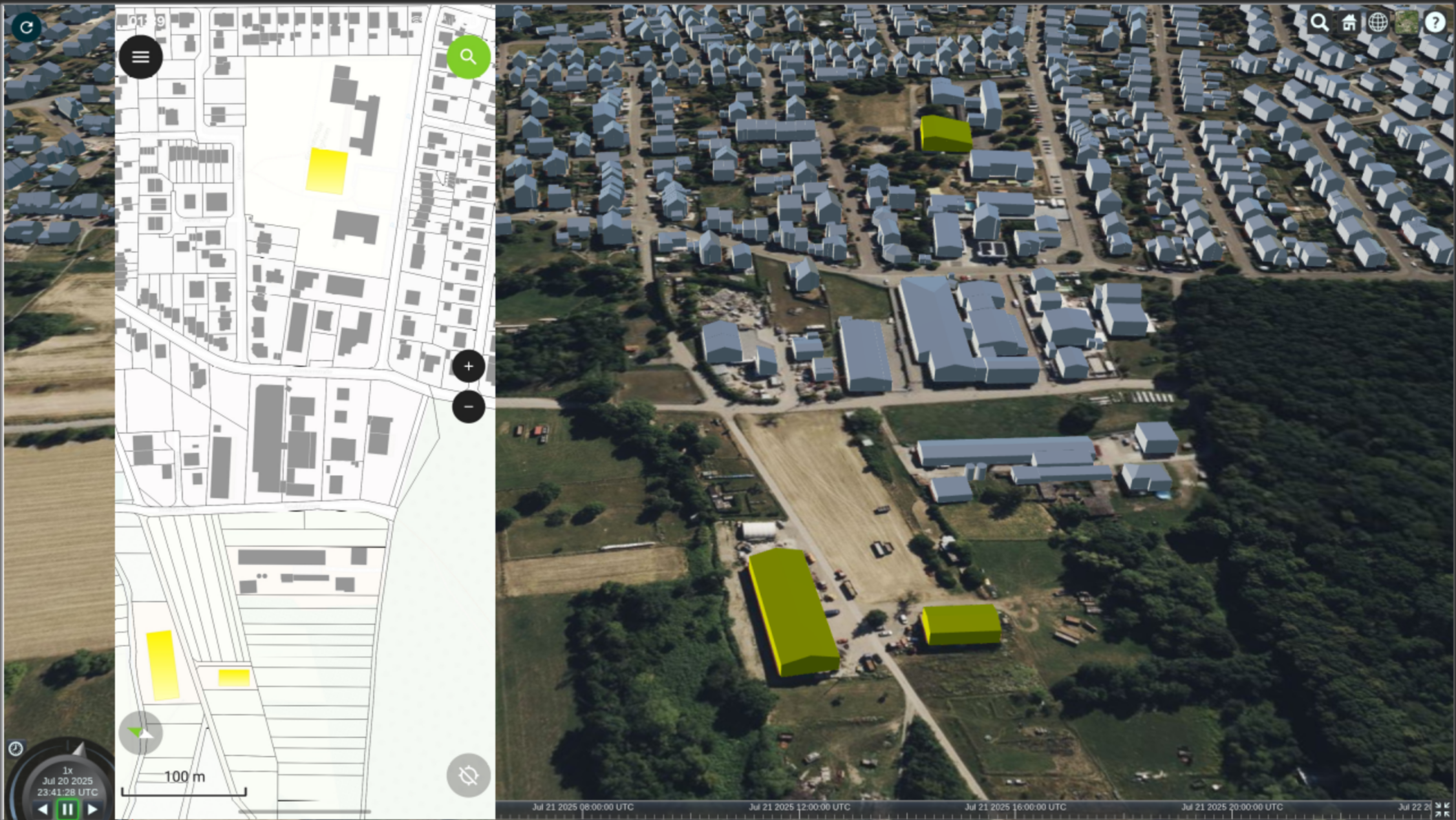
"title": "Integrating QFieldCloud with CesiumJS for Vacant Building App",
"subtitle": "Connecting Mobile Data Collection and 3D Visualization with Django REST APIs",
"description": "We are integrating the QFieldCloud app for the \"vacant building app\" with CesiumJS through Django REST APIs, QGIS, and React JS. This setup enables seamless data collection on the go and powerful 3D visualization, providing real-time insights into vacant buildings, all accessible from a web interface for effective decision-making and planning.",
"bullet_points": "",
"price": null,
"image": "https://backend.gisworld-tech.com/media/core/main_content/qfieldclould_cesium.png",
"video": null,
"image_size": "300px",
"url": "https://gisworld-tech.com/web-gis/qfieldcloud-cesium",
"mui_icon_name": null,
"redirect_text_1": "Start App",
"navigate_to_1": null,
"redirect_text_2": null,
"navigate_to_2": null
},
{
"id": 34,
"is_text_left_side": true,
"is_text_top_side": false,
"order": 4,
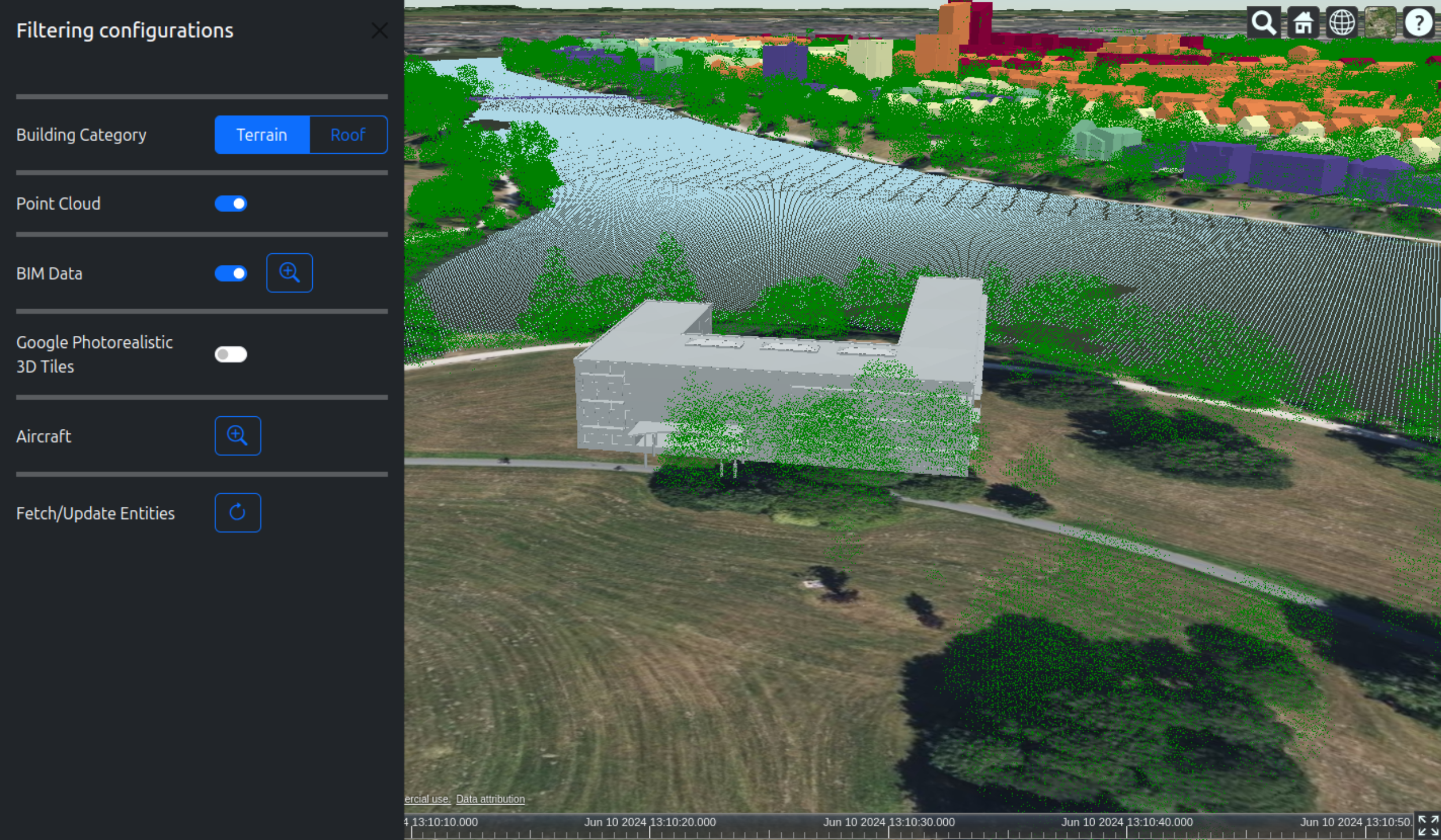
"title": "Viewer, 3DTiles, Styling and Filtering, CityGML, LiDAR Data, and BIM Data",
"subtitle": "CesiumJS Comprehensive App",
"description": "You can clamp CityGML models to terrain and apply advanced styling and filtering to 3D tiles. Visualize LiDAR point clouds and integrate BIM models for detailed urban planning. Create interactive, movable objects from 2D data in QGIS or web GIS tools, and add real-time dynamic entities to CesiumJS with RESTful APIs for continuous updates.",
"bullet_points": "",
"price": null,
"image": "https://backend.gisworld-tech.com/media/core/main_content/part_10_MvUPrwu.png",
"video": null,
"image_size": "300px",
"url": "https://cesium.gisworld-tech.com/part_10/",
"mui_icon_name": null,
"redirect_text_1": "Start App",
"navigate_to_1": null,
"redirect_text_2": null,
"navigate_to_2": null
}
]
},
{
"id": 6,
"order": 4,
"type": "one_side_text_one_side_image",
"title": "GIS inteligence solutions",
"subtitle": "Revolutionizing STEG's service areas, from urban planning to property valuation",
"description": "",
"items": [
{
"id": 16,
"is_text_left_side": true,
"is_text_top_side": false,
"order": 1,
"title": "Urban planning",
"subtitle": "Geospatial based solution for Urban planning projects",
"description": "GIS provides urban planners with tools to analyze data, visualize complex scenarios and thus pave the way for a more sustainable and resilient future. If cities used to be planned with CAD, today we do it with geospatial information systems.",
"bullet_points": "",
"price": null,
"image": "https://backend.gisworld-tech.com/media/core/main_content/GIS_solution_for_urban_400x300.png",
"video": null,
"image_size": "300px",
"url": null,
"mui_icon_name": null,
"redirect_text_1": null,
"navigate_to_1": null,
"redirect_text_2": null,
"navigate_to_2": null
},
{
"id": 17,
"is_text_left_side": false,
"is_text_top_side": false,
"order": 2,
"title": "Urban renewal",
"subtitle": "All you need for urban redevelpment",
"description": "Redevelopment areas in 3D? \r\nPhotovoltaic potential? \r\nLocal heating networks in existing areas? \r\nNo problem, GIS as software provides the appropriate form of representation so that the right future decisions can be made for a livable neighborhood.",
"bullet_points": "",
"price": null,
"image": "https://backend.gisworld-tech.com/media/core/main_content/3D_redevelopment_area.png",
"video": null,
"image_size": "300px",
"url": null,
"mui_icon_name": null,
"redirect_text_1": null,
"navigate_to_1": null,
"redirect_text_2": null,
"navigate_to_2": null
},
{
"id": 18,
"is_text_left_side": false,
"is_text_top_side": false,
"order": 3,
"title": "Land and Project Development",
"subtitle": "Sustainable Urban Land Development with GIS-based Solutions",
"description": "Modern land development no longer occurs on open fields but through infill development. GIS-based methods for sustainable land use and urban planning are now standard practice with us, and we would be happy to demonstrate the benefits to you.",
"bullet_points": "",
"price": null,
"image": "https://backend.gisworld-tech.com/media/core/main_content/Urban_land_and_project_development.png",
"video": null,
"image_size": "300px",
"url": null,
"mui_icon_name": null,
"redirect_text_1": null,
"navigate_to_1": null,
"redirect_text_2": null,
"navigate_to_2": null
},
{
"id": 19,
"is_text_left_side": true,
"is_text_top_side": false,
"order": 4,
"title": "Property Valuation",
"subtitle": "GIS Solutions for Accurate Property Valuation",
"description": "Our specialists provide support in property valuation, publication of land value maps, and the application of GIS-based methods in low-price areas. We offer advanced solutions for a wide range of real estate applications.",
"bullet_points": "",
"price": null,
"image": "https://backend.gisworld-tech.com/media/core/main_content/Property_Valuation.png",
"video": null,
"image_size": "300px",
"url": null,
"mui_icon_name": null,
"redirect_text_1": null,
"navigate_to_1": null,
"redirect_text_2": null,
"navigate_to_2": null
}
]
},
{
"id": 3,
"order": 5,
"type": "multi_images",
"title": "Academy",
"subtitle": "All you need to get started with geospatial technologies.",
"description": "",
"items": [
{
"id": 1,
"is_text_left_side": false,
"is_text_top_side": false,
"order": 1,
"title": "CesiumJS",
"subtitle": "",
"description": "",
"bullet_points": null,
"price": null,
"image": "https://backend.gisworld-tech.com/media/core/main_content/cesiumjs.webp",
"video": null,
"image_size": "180px",
"url": "https://www.youtube.com/playlist?list=PLCxnvDblgXGRhsfSGYUmHCgtoQytu9VxW",
"mui_icon_name": null,
"redirect_text_1": null,
"navigate_to_1": null,
"redirect_text_2": null,
"navigate_to_2": null
},
{
"id": 10,
"is_text_left_side": false,
"is_text_top_side": false,
"order": 2,
"title": "QFieldCloud",
"subtitle": "",
"description": "",
"bullet_points": null,
"price": null,
"image": "https://backend.gisworld-tech.com/media/core/main_content/qfield_clould.webp",
"video": null,
"image_size": "180px",
"url": "https://www.youtube.com/playlist?list=PLCxnvDblgXGTbTSJXhjMFtfrxOXcnpiuA",
"mui_icon_name": null,
"redirect_text_1": null,
"navigate_to_1": null,
"redirect_text_2": null,
"navigate_to_2": null
},
{
"id": 2,
"is_text_left_side": false,
"is_text_top_side": false,
"order": 2,
"title": "QGIS",
"subtitle": "",
"description": "",
"bullet_points": "",
"price": null,
"image": "https://backend.gisworld-tech.com/media/core/main_content/ChatGPT_Image_Mar_27_2025_10_20_41_AM.png",
"video": null,
"image_size": "180px",
"url": "https://www.youtube.com/playlist?list=PLCxnvDblgXGQHKgnbRTFB6a6AeKqYy9-9",
"mui_icon_name": null,
"redirect_text_1": null,
"navigate_to_1": null,
"redirect_text_2": null,
"navigate_to_2": null
},
{
"id": 3,
"is_text_left_side": false,
"is_text_top_side": false,
"order": 3,
"title": "PyQGIS",
"subtitle": "",
"description": "",
"bullet_points": null,
"price": null,
"image": "https://backend.gisworld-tech.com/media/core/main_content/pyqgis.webp",
"video": null,
"image_size": "180px",
"url": "https://www.youtube.com/playlist?list=PLCxnvDblgXGRzlmmVgAxpTJc60Rklxe8R",
"mui_icon_name": null,
"redirect_text_1": null,
"navigate_to_1": null,
"redirect_text_2": null,
"navigate_to_2": null
},
{
"id": 4,
"is_text_left_side": false,
"is_text_top_side": false,
"order": 4,
"title": "gpkg",
"subtitle": "",
"description": "",
"bullet_points": null,
"price": null,
"image": "https://backend.gisworld-tech.com/media/core/main_content/gpkg.webp",
"video": null,
"image_size": "180px",
"url": "https://www.youtube.com/playlist?list=PLCxnvDblgXGTvOEU5S0_zGrjQ51TFyKBu",
"mui_icon_name": null,
"redirect_text_1": null,
"navigate_to_1": null,
"redirect_text_2": null,
"navigate_to_2": null
},
{
"id": 7,
"is_text_left_side": false,
"is_text_top_side": false,
"order": 5,
"title": "Python",
"subtitle": "",
"description": "",
"bullet_points": null,
"price": null,
"image": "https://backend.gisworld-tech.com/media/core/main_content/python.webp",
"video": null,
"image_size": "180px",
"url": "https://www.youtube.com/playlist?list=PLCxnvDblgXGTfJcwQx99Rmswdth7CmF_8",
"mui_icon_name": null,
"redirect_text_1": null,
"navigate_to_1": null,
"redirect_text_2": null,
"navigate_to_2": null
},
{
"id": 9,
"is_text_left_side": false,
"is_text_top_side": false,
"order": 6,
"title": "SQL",
"subtitle": "",
"description": "",
"bullet_points": null,
"price": null,
"image": "https://backend.gisworld-tech.com/media/core/main_content/sql.webp",
"video": null,
"image_size": "180px",
"url": "https://www.youtube.com/playlist?list=PLCxnvDblgXGS9nYG8Fi3hLaLFVE-n5Drv",
"mui_icon_name": null,
"redirect_text_1": null,
"navigate_to_1": null,
"redirect_text_2": null,
"navigate_to_2": null
}
]
},
{
"id": 18,
"order": 6,
"type": "simple_card_inline",
"title": "Hybrid Course (22-23 October)",
"subtitle": "All you need to getting start with QGIS, PyQGIS, QField, and CeisumJS",
"description": "",
"items": [
{
"id": 55,
"is_text_left_side": false,
"is_text_top_side": false,
"order": 1,
"title": "Day 1",
"subtitle": "Introduction to QGIS",
"description": "",
"bullet_points": "Geospatial Data Visualization;Working with Attributes, Expressions and Filtering;Designing;Professional Maps;Basic Spatial Analysis: Buffers, Overlays, and Queries;Collect field data using QField & QField Cloud",
"price": null,
"image": null,
"video": null,
"image_size": null,
"url": null,
"mui_icon_name": null,
"redirect_text_1": null,
"navigate_to_1": null,
"redirect_text_2": null,
"navigate_to_2": null
},
{
"id": 56,
"is_text_left_side": true,
"is_text_top_side": false,
"order": 2,
"title": "Day 2",
"subtitle": "Advanced QGIS Techniques",
"description": "",
"bullet_points": "Automated Map Creation with the Atlas Tool;Import CAD files and work with 3D data;Advance Symbology in QGIS;Integrating QGIS and CesiumJS for 3D Visualization;Create plugins & automate workflows with PyQGIS (Python);Integrating AI Applications with QGIS",
"price": null,
"image": null,
"video": null,
"image_size": null,
"url": null,
"mui_icon_name": null,
"redirect_text_1": "Register just for 399€",
"navigate_to_1": "/contact",
"redirect_text_2": null,
"navigate_to_2": null
}
]
},
{
"id": 1,
"order": 7,
"type": "one_side_text_one_side_image",
"title": "Why you'll love working with us",
"subtitle": "Quality, Life-Time Support, and Faster Result",
"description": "",
"items": [
{
"id": 5,
"is_text_left_side": false,
"is_text_top_side": false,
"order": 1,
"title": "Geospatial Learning Path",
"subtitle": "Master Geospatial Skills Step-by-Step",
"description": "Structured learning path to build geospatial expertise for professionals.",
"bullet_points": "",
"price": null,
"image": "https://backend.gisworld-tech.com/media/core/main_content/1_geospatial_learning_path.png",
"video": null,
"image_size": "300px",
"url": null,
"mui_icon_name": "School",
"redirect_text_1": null,
"navigate_to_1": null,
"redirect_text_2": null,
"navigate_to_2": null
},
{
"id": 6,
"is_text_left_side": false,
"is_text_top_side": false,
"order": 2,
"title": "Tailored Educational Content",
"subtitle": "Customized Educational Videos",
"description": "Custom videos to train teams and promote geomatics products",
"bullet_points": "",
"price": null,
"image": "https://backend.gisworld-tech.com/media/core/main_content/2_tailored_educational_content.png",
"video": null,
"image_size": "300px",
"url": null,
"mui_icon_name": "CastForEducation",
"redirect_text_1": null,
"navigate_to_1": null,
"redirect_text_2": null,
"navigate_to_2": null
},
{
"id": 11,
"is_text_left_side": true,
"is_text_top_side": false,
"order": 3,
"title": "Practical Geospatial Skills",
"subtitle": "Learn By Doing with Real-World Projects",
"description": "Hands-on lessons and projects to solve real geospatial challenges.",
"bullet_points": "",
"price": null,
"image": "https://backend.gisworld-tech.com/media/core/main_content/3_practical_geospatial_skills.png",
"video": null,
"image_size": "300px",
"url": null,
"mui_icon_name": "Architecture",
"redirect_text_1": null,
"navigate_to_1": null,
"redirect_text_2": null,
"navigate_to_2": null
},
{
"id": 8,
"is_text_left_side": true,
"is_text_top_side": false,
"order": 4,
"title": "Grow Your Geomatics Business",
"subtitle": "Empower Your Company with Educational Tools",
"description": "Tools and tutorials to support product development and business growth.",
"bullet_points": "",
"price": null,
"image": "https://backend.gisworld-tech.com/media/core/main_content/4_grow_your_geomatics_business.webp",
"video": null,
"image_size": "300px",
"url": null,
"mui_icon_name": "TrendingUp",
"redirect_text_1": null,
"navigate_to_1": null,
"redirect_text_2": null,
"navigate_to_2": null
}
]
},
{
"id": 9,
"order": 8,
"type": "simple_card_inline",
"title": "Contact Us",
"subtitle": "Are you interested to start a new cooperation",
"description": "",
"items": [
{
"id": 29,
"is_text_left_side": false,
"is_text_top_side": false,
"order": 1,
"title": "Silver",
"subtitle": "",
"description": "",
"bullet_points": "Social Media Promotion;\r\nVideo Support;\r\nWebsite Presence;\r\nAnnual Analytics Report;\r\n-;\r\n-;\r\n-",
"price": 1999.0,
"image": null,
"video": null,
"image_size": null,
"url": null,
"mui_icon_name": null,
"redirect_text_1": "Join us",
"navigate_to_1": "/contact",
"redirect_text_2": null,
"navigate_to_2": null
},
{
"id": 30,
"is_text_left_side": false,
"is_text_top_side": false,
"order": 2,
"title": "Gold",
"subtitle": "",
"description": "",
"bullet_points": "Social Media Promotion;\r\nVideo Support;\r\nWebsite Presence;\r\nAnnual Analytics Report;\r\nBiannual Analytics Report;\r\nExclusive Newsletter Feature;\r\n-",
"price": 2599.0,
"image": null,
"video": null,
"image_size": null,
"url": null,
"mui_icon_name": null,
"redirect_text_1": "Join us",
"navigate_to_1": "/contact",
"redirect_text_2": null,
"navigate_to_2": null
},
{
"id": 31,
"is_text_left_side": false,
"is_text_top_side": false,
"order": 3,
"title": "Platinum",
"subtitle": "",
"description": "",
"bullet_points": "Social Media Promotion;\r\nVideo Support;\r\nWebsite Presence;\r\nAnnual Analytics Report;\r\nBiannual Analytics Report;\r\nExclusive Newsletter Feature;\r\nPriority Support",
"price": 2999.0,
"image": null,
"video": null,
"image_size": null,
"url": null,
"mui_icon_name": null,
"redirect_text_1": "Join us",
"navigate_to_1": "/contact",
"redirect_text_2": null,
"navigate_to_2": null
}
]
}
]